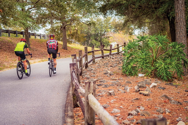
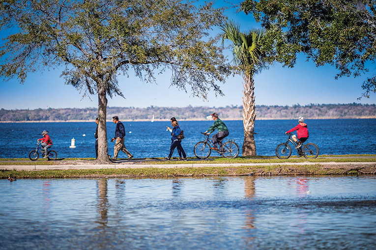
The West Orange Trail is actually part of the Coast to Coast Connector (ROBERTO GONZALEZ)
Metro Orlando boasts more than 250 miles of paved bike paths, more lie just outside our area, and there’s a coast-to-coast connector in the works. It’s time to hit the trail. By Dan Tracy
My first bicycle was a second-hand Huffy with a red steel frame and silver fenders that my older brother had outgrown.
Raised in a quiet, middle-class neighborhood in a town north of Cincinnati, I rode that bike far and wide, on sidewalks and streets, fields and front lawns, through creeks, on gravel and mud, pretty much anywhere I wanted.
Baseball trading cards clacking in the tire spokes, that bike was everything to me. It was transportation. It was entertainment and fun. It was freedom.
More decades than I care to count later, I still ride a bike, though one that is considerably more sophisticated than my old coaster-brake Huffy. My specialized bike has a carbon frame, 21 gears, hand brakes and thin tires. I wear a helmet, synthetic-blend high-tech jerseys and shorts and shoes that clip into the pedals.
But riding a bike in the Ohio of my youth is an entirely different experience than negotiating the congested, frequently mean streets of Metro Orlando, circa 2020. Orlando, as many know, is not well suited for bikes, its road network deemed “dangerous by design” by one national smart-growth organization.
Like virtually all of Florida, Greater Orlando grew up post World War II, firmly believing in the concept that the automobile was the only way to move about. The region, as a result, has lots of wide, multi-lane roads that encourage motorists to travel at increasingly high rates of speed.
There was little to no room made for bicyclists, much less people on foot.
So what’s a cyclist to do? Especially one who is not comfortable sharing pavement with motorists who are sometimes more intent on reading their latest text message than keeping their eyes on the road?
Welcome to so-called multi-use paths that are open to bikes, walkers, runners, roller-bladers and the like—but not motorized vehicles.
Florida has more than 55 paved bike paths covering 816 miles. Another 35 paths are being built, with the potential to add 440 more miles to the overall network, according to the Rails to Trails Conservancy.
Metro Orlando is home to some 30 trails covering 250-plus miles, the paths ranging from short in-city urban trails of a mile or three to the 28-mile Cross Seminole Trail that goes through Oviedo, Winter Springs and various suburbs.
The city of Orlando alone has 40 miles of off-street trails and more than 260 miles of bicycle lanes. Each month, according to city counts, bikers take more than 220,000 trips on the network.
The big appeal of bike-only paths over bike lanes that are shunted to the right side of the road is that except for intersections, a cyclist never has to worry about being knocked over by a motorist on a bike path.
Instead, he or she is free to ride hither and yon, rolling through a wide variety of terrain, from the hills of southern Lake County to the flat, bucolic stretches of the East Central Regional Rail Trail that links DeBary with Titusville.
If you look hard enough, there’s a path for about every level of rider, from gonzo 30 mph racers to weekend warriors to parents puttering along with their youngsters tottering on training wheels. There’s even room for aging Baby Boomers and Gen Xers who may be drawn to bikes because their knees and hips are worn out by running or other pounding exercises.
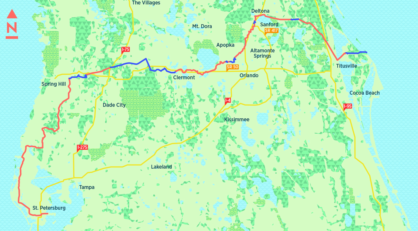
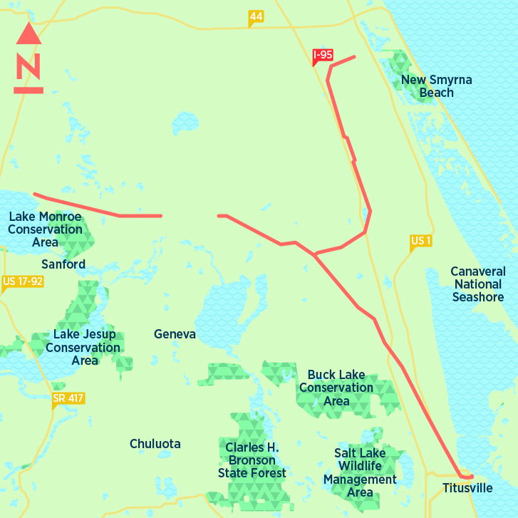
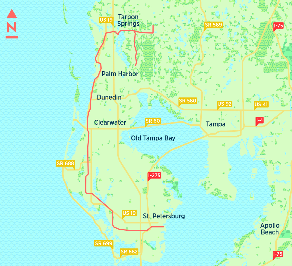
The biggest, most ambitious bike path in Central Florida remains very much in the works: the Coast to Coast Connector, which would run east to west from Titusville to St. Petersburg, making it the first statewide trail of its kind in the United States.
Approximately 250 miles long, the so-called C2C is slated to close gaps and link at least 17 existing bike paths. Relying largely on state grants, the $50 million project is more than 80 percent complete. But it’s unclear when it will be finished, although the Florida Department of Transportation has set aside $29.5 million for trail work through 2023-2024, and some sections are also being completed as part of roadway projects, separate from trail funding.
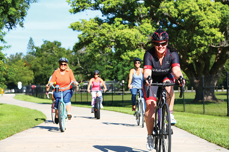
Lisa Portelli, an avid Winter Park cyclist who averages 200 miles weekly on her bike, says she prefers trails whenever or wherever she can find them.
“Let’s face it, it’s dangerous. We are dangerous by design,” Portelli says, echoing the term coined by Smart Growth America, a nonprofit that publishes reports on biking and pedestrian safety trends nationwide.
Portelli, who has ridden nearly 290 miles during one 24-hour period, says she loves the trails because they free her to engage in long conversations with her bike mates without having to constantly worry about the traffic around her.
“It’s just really great to get away from screen time,” she says. “It’s pure medicine for health.”
Sean Gibbs is another trail enthusiast. A paraplegic who hand-cycles almost daily, he lives just a few yards from the site of his favorite workout, the West Orange Trail in Winter Garden.
“I try to stay out of the streets,” he says. “I have kids and a wife who need me to come home at night.”
Becky Afonso, executive director of the Florida Bicycle Association, says bike paths are not an especially new concept in the state. The first one opened in 1984, joining Tallahassee with St. Marks to the south.
The trail was laid over an abandoned rail line, becoming the template for many of Florida’s bike paths. Two others that followed Tallahassee to St. Marks were the Pinellas Trail in Pinellas County, which is celebrating its 30th anniversary this year, and the Van Fleet Trail in Polk County, which opened in 1992.
Bike trails are possible because of a concept known as rail-banking, which was approved by Congress in 1983 as a way for a railroad and a trail agency to convert out-of-service routes into bike/people-only paths.
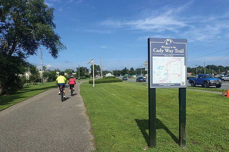
One of the first bike paths in Metro Orlando was the Cady Way Trail, which opened in 1994 and ran between the Fashion Square Mall and Ward Memorial Park. It has since been extended to join the Cross Seminole Trail.
Afonso, who lives in Oldsmar, near Tampa, often rides the main bike trail in her town, though she is not averse to getting on the roads.
“We don’t talk enough about how enjoyable bike riding is,” she says. “I just like the fact that I am not in my car.”
Seminole Wekiva Trail. (MEGAN STOKES)
Local
14 miles
he San Sebastian Trailhead near the southernmost point of the Seminole Wekiva Trail greets cyclists with a view of the Little Wekiva River from a picturesque bridge. Heading north, the trail is well shaded and quiet but traffic increases near the 40-acre Sanlando Park, known for hosting large tennis tournaments on its six courts. It also has volleyball, racquetball and a nature trail. Next door is the Seminole County Softball Complex. There’s also some foot traffic in this area from a large business complex where employees escape their office for some fresh air on the trail.
For entertainment beyond nature, riders on the Paint the Trail portion of the Seminole Wekiva will see the likes of Audrey Hepburn, Cheech and Chong, The Beatles, James Bond, Kermit the Frog, Muhammad Ali and the shark from Jaws, all in a few pedals of a bicycle. With more than 1,000 vibrant paintings and counting, local artist Jeff Sonksen has transformed wooden privacy fencing along the center of Seminole Wekiva into an art exhibit packed with iconic, inspirational and political images. The sprawling white angel wings sculpture and the wooden monarch butterfly wings—planted in front of a series of dramatically painted endangered species images—are hotspots for selfies. The paintings are between E.E. Williamson Road and the Jones Trailhead off Markham Woods Road in Longwood.
The Seminole Wekiva has two underpasses—one under State Road 434 and another under Lake Mary Boulevard. These tiny tunnels are fun to go through since, as Floridians, we rarely get to do anything underground. Both areas have some shopping and restaurant options.
The northern point of the trail provides access to the Cross Seminole Trail (just north of County Road 46) and the Lower Wekiva River State Park. Megan Stokes
Orlando Urban Trail. (PHOTO COURTESY OF CITY OF ORLANDO)
Local
4 miles
his trail is broken into several sections, going from city to serene in four miles and serving as a connector to restaurants, shopping and culture. Heading north from Magnolia Avenue, the surroundings are very…urban. This section isn’t the most scenic—it parallels railroad tracks on one side and Lake Highland Drive on the other and is dotted with ballfields and fenced industrial buildings. But it conveniently hugs the backside of Ivanhoe Village, which is packed with cool places to eat, drink and shop. A quick jaunt off the trail can lead to The Backhaus, a German deli and bakery; The Hammered Lamb, known for its mean Bloody Mary bar; and a cute stationery store called Paper Goat Post. Cyclists can also connect to Lake Ivanhoe Trail here for a waterfront ride.
Farther along, just before Virginia Drive, is a quirky mural featuring black cats and a little path leading to Quantum Leap Wine Company. There’s a flashing pedestrian crossing sign at Virginia, where bicyclists can go off the trail for lunch and libations at Grape & the Grain, Santiago’s Bodega or Ten10 Brewing Company. Back on the trail, there are several more restaurants and bars, including First Watch, Firebird’s Wood Fired Grill and The Brass Tap.
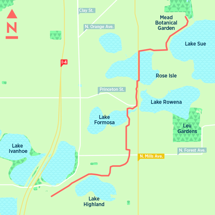
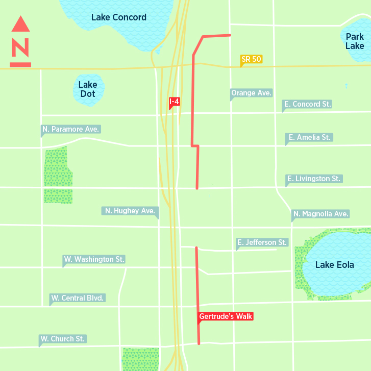
The trail’s mood soon changes from buzzing to calm as it ambles around a total of four lakes and four parks. Stop on the bridge over Lake Formosa for beautiful sunset views and then ride through the Mennello Museum of American Art’s sculpture garden. Although the next bit of trail runs along busy Mills Avenue, views of Lake Rowena and Lake Estelle make it pleasant. The trail then goes through the Orwin Manor neighborhood along Dorchester Street to Lake Shore Drive with great views of Lake Sue before ending at the beautiful Mead Botanical Garden—a perfect picnic spot.
The southern part of the Urban Trail begins on Church Street with what’s known as Gertrude’s Walk, featuring two murals. It ends a few blocks north at Jefferson Street, then picks up again at Livingston Street, continuing to the Colonial Drive overpass and ending at Orange Avenue. The gap between there and the beginning of the northern leg at Magnolia Avenue is in the design stage and will include signalized crossings. Megan Stokes
Cross Seminole Trail. (ROBERTO GONZALEZ)
Local
28 miles
he Cross Seminole Trail is a tour through Central Florida suburbs, shaded paths and parks, with much of it running on reclaimed railroad and power line easements connecting Goldenrod, Oviedo, Winter Springs and Lake Mary. The path links to Winter Park’s Cady Way Trail to the south and eventually leads to Lake Monroe in Sanford.
The Cross Seminole Trail begins near the busy intersection of Aloma Avenue (State Road 426) and Howell Branch Road east of Winter Park. It winds northeast to downtown Oviedo, then juts northwest through downtown Winter Springs and a series of parks: Central Winds, Soldiers Creek, Big Tree and Greenwood Lakes parks, and ends at Lake Monroe Wayside Park, west of the Central Florida Zoo in Sanford. In between, you will be witness to Orlando’s modern sprawl peppered with stretches of Florida wilderness. Some tree-lined sections are like riding through a heavily canopied forest. Portions are designated as a Florida National Scenic Trail.
A fun 14-mile-round-trip ride starts near downtown Oviedo at the intersection of State Roads 426 and 434—near the trail’s 7-mile marker—and ends at Layer Elementary School, the trail’s 14-mile point on State Road 419 in Winter Springs. This is where a six-tenths of a mile, $1 million “missing link” is tentatively slated for a November completion. Until then, riders must brave busy S.R. 419 or navigate down Old Sanford/Oviedo Road, through an industrial recycling area and a rough dirt path until the paved trail resumes through the Spring Hammock Preserve and connects to Soldiers Creek Park and on to Lake Mary.
For the suggested 14-mile Oviedo-Winter Springs ride, park in the vacant, far corner of the Oviedo Shopping Center (115 Geneva Drive) housing the Oviedo Post Office, an antique mall and an Ace Hardware store, and you can jump on the trail behind the huge CrossLife Church. Nearby Santorini Restaurant and Mad Hatter’s Pizza are convenient places to eat, along with the iconic Townhouse Restaurant across the street. Another place to park and access the bike path is two miles west at the Black Hammock Trailhead, tucked along S.R. 434 between The Watermark assisted living facility and S.R. 417, complete with bathrooms, a small playground and a bicycle repair station.
The ride west goes through Oviedo and the Tuscawilla development. A lush tree canopy and wildlife including tortoises, squirrels, birds, rabbits, horses and an occasional snake make it easy to forget that you are riding through housing developments. The Howell Creek Trestle, a small roofed resting area, overlooks a tranquil stream amid oaks and palms. On hot days, some riders climb down to the creek below and cool their feet.
About 1.1 miles further west, there is a bicycle/pedestrian bridge over S.R. 434. The trail meanders behind Winter Springs Town Center, its restaurants (Starbucks, McDonald’s, Big City Pizza, Subway,Tijuana Flats and others) and apartments. It continues past Winter Springs High School, Central Winds Park and dead ends at Layer Elementary School, the beginning of the unpaved missing trail link. When going through the parks, take a break and watch a baseball or soccer game. Jim Leusner
10 Trail Tips to Stay Safe
- Practice courtesy, patience and respect for others.
- Ride single file on the right, announcing to others before passing on the left. Be predictable to other trail users.
- Yield to traffic when crossing intersections. Beware of heavy vegetation that may prevent motorists from seeing you.
- Travel with a buddy.
- Carry two bottles of water and your cell phone.
- Watch for stopped pedestrians, loose dogs, or debris that has fallen after a storm.
- If you’re riding at night, use a white front bike light, a red rear light and a helmet light.
- If you’re part of a group, take up only half the trail and ride single file when traffic is heavy.
- When stopping, move completely off the trail.
- Keep pets on a short leash. “ Megan Stokes
- Sources: Florida Bicycle Association; Rails to Trails Conservancy, Cycle Savvy
Cady Way Trail (JOHN KEATLEY/FLORIDAHIKES.COM)
Local
2.5 miles
7.5 miles
he loop around Baldwin Park’s namesake scenic lake is a safe, popular trail perfect for any level of rider wanting to rack up some easy miles. It circles environmentally protected conservation areas, passing the Village Center, Veterans Administration Clinic and Lake Baldwin Dog Park (watch out for kids and canines). Much of the trail is unshaded, so on a hot summer day it’s best to ride in the morning or evening.
The dog park, on the trail’s northwest corner, provides a thick oak canopy to cool riders. There are restrooms, a water fountain and a fenced playground here, and it’s a fun place to watch dogs play or to observe sailboaters and kayakers launching from a boat ramp.
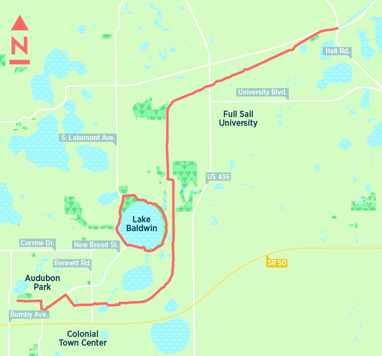
Also on the route is the 4-acre Orlando Veterans’ Memorial Park, with numerous monuments dedicated to members of America’s military. Stop and learn about the history of the Vietnam War etched in black marble, or see tributes to World War II, Korean War and Pearl Harbor veterans and various military branches. (Baldwin Park is the former site of the Orlando Naval Training Center, which trained 650,000 recruits before closing in the mid-1990s.)
There are plenty of restaurants nearby along New Broad Street, including Five Guys, Gator’s Dockside and Colibri Mexican Cuisine.
If you get tired of riding in circles, you can ride to Baldwin Park Street one mile east of the town center heading toward Semoran Boulevard, then jump on the Cady Way Trail. That 7.5-mile path begins at Lake Druid Park west of Orlando Fashion Square and loops around the exterior of the Baldwin Park development. It stretches north to Cady Way Park, through the quaint Winter Park Pines neighborhood and over the Semoran Boulevard bike bridge. This northern stretch through Goldenrod’s industrial district links to the Cross Seminole Trail at Howell Branch Road/Hall Road and Aloma Avenue. Jim Leusner
Something’s Squirrelly
When asked to name the biggest hazard on Orlando’s bike trails, Orange Cycle owner Deena Breed doesn’t hesitate:“Squirrels!” They’re common, completely unpredictable and “they can take you down,” Breed laments. “I have no advice on what to do. One time a squirrel came out and ran along the front wheel of my friend’s bike. All we could think of was to scream, and luckily it ran off. Everybody’s got a squirrel story.” “M.S.
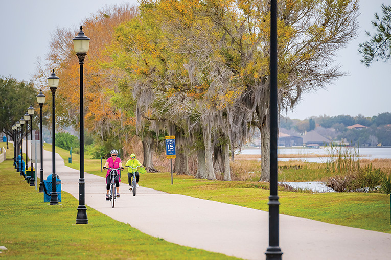
PHOTO BY ROBERTO GONZALEZ
Local
13 miles
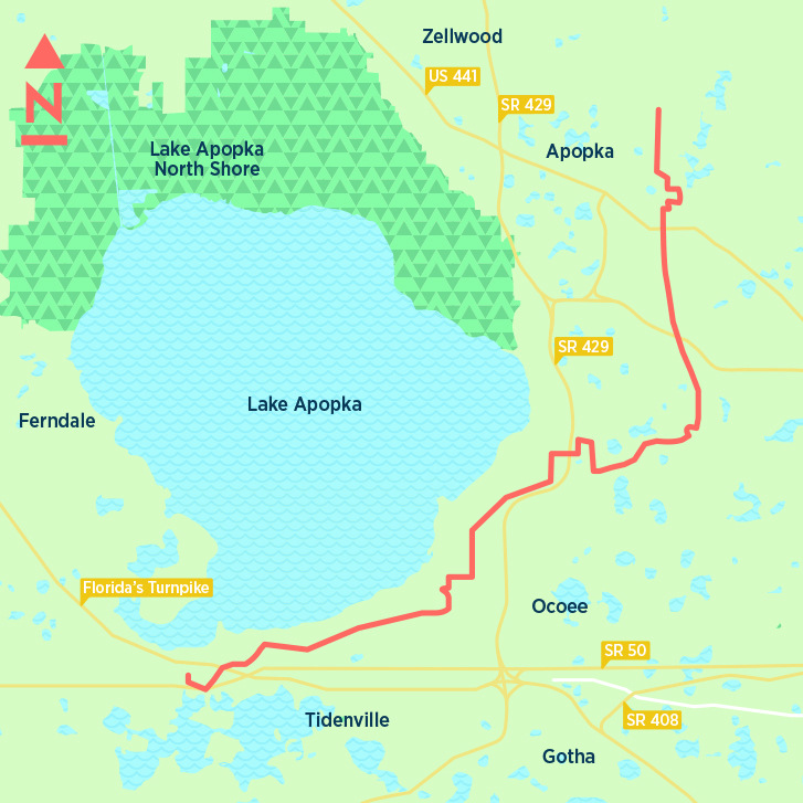
If it’s hills you’re after, the South Lake Trail is where you want to take your bike. Unlike the mostly flat terrain of Metro Orlando, the South Lake Trail, which also goes by the Lake Minneola Scenic Trail, has plenty of elevation changes, or to be more blunt, ups and downs. So tackling this link means shifting your bike’s gears a good bit, although there are some level sections, especially around Lake Minneola, the site of numerous triathlons.
If you are feeling adventurous, hop off the trail and ride around the north, west and south sides of Lake Minneola. The road is lightly traveled and most of the drivers are used to seeing cyclists and usually give them plenty of room when passing.
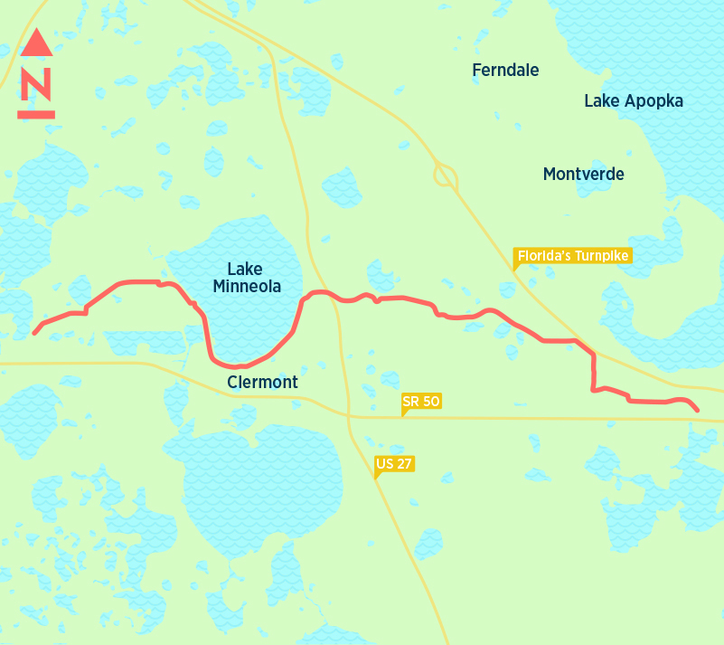
The Clermont and Minneola sections also offer some nice restaurants for riders, as well as a park with restrooms and a playground along the eastern shore. Eateries with lake views include Lilly’s on the Lake, Tiki Bar Grill, and Cheeser’s Palace Cafe. A mile or two away, along U.S. 27, is a cluster of restaurants, some of the chain variety.
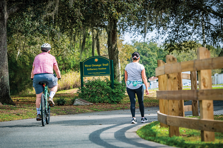
There are two ways to get to the trail. Park at the Killarney Station, just off State Road 50 east of Clermont. Or ride your bike into Killarney on the West Orange Trail and continue west. Leaving from downtown Winter Garden adds about 5 miles to your trek.
The eastern part of the trail runs through what used to be pasture and groves, but now is mostly subdivisions. Though not as bucolic as it once was, much of the ride remains pleasantly shaded, a big deal during our brutal summers. Dan Tracy
West Orange Trail (ROBERTO GONZALEZ)
Local
22 miles
With 150,000 monthly users, this is one of the most popular trails in the area—and even the country, according to the Rails-to-Trails Conservancy, which includes West Orange on its “Best Trails in the U.S.” list.
The western starting point, Killarney Station (where bike rentals are available), is typically buzzing with cyclists and joggers on weekends. After a small hill, the trail’s converted railroad bridge crosses over Florida’s Turnpike, then at 1.4 miles passes the Oakland Nature Preserve, which has a hiking trail that ends at a dock overlooking Lake Apopka. Just after that is Briley Farm—an easy-to-miss gem where riders can sometimes see zebras, ostriches and long-horned Watusi cattle. The beautiful tree canopy that forms here continues all the way to Oakland’s charming downtown (mile marker 2). In this historic town, founded in 1886, you’ll find a Spanish-style Town Hall building, a brick-paved garden with a bicycle-themed steel structure as its centerpiece—“Cloudcycle” by artist James Lashley—and the Living Bench, which is a tree stump with intricate carvings, including a realistic-looking alligator.
A mile and a half farther is a butterfly garden—a peaceful place to stretch your legs—then you’ll pass a small orange grove before arriving in downtown Winter Garden. Don’t pass up the Plant Street Market, which boasts a plethora of restaurants (selling everything from ceviche and smoothies to pizza and gourmet mac and cheese), specialty shops (including a butcher, chocolatier and local honey), and bars of all kinds—oxygen, coffee and beer (Crooked Can Brewing Company is the anchor). The market draws tons of families and people with dogs because of its large outdoor dining area.
The trail then continues down the center of Plant Street, past a mosaic water fountain surrounded by swinging benches and flowers, the city’s iconic clock tower, and a wide selection of restaurants. After lunch, head out on the eastern leg of the trail, highlighted by the Path of Life garden at Chapin Station. Just before this is the Division Street intersection where there’s a decent-sized hill and a split in the trail for views of the expansive Lake Apopka. Staying east, you’ll reach the Apopka-Vineland Outpost and then the lovely Chua Bao An Buddhist Temple. The trail splits again at Apopka Vineland Road. Staying straight, you’ll find the nationally renowned Clarcona Horseman’s Park, which hosts monthly horse shows and is a good turnaround point for a hearty 30-mile round trip. If you’re feeling particularly energetic, follow the trail across Apopka Vineland Road and continue through Apopka to the end of the trail, nearly reaching Wekiwa Springs State Park. Planned expansions will extend the trail to Kelly Park and eventually into Lake County. Megan Stokes
Road Rules
When you’re off the beaten path, be wary. By Megan Stokes
Florida’s cyclist fatalities were the highest in the nation at 125 in 2017, according to a federal report. Caution is essential when you’re not on a bike trail, either by choice or necessity. Local experts weigh in on best cycle practices on the road:
- Always ride in the same direction as traffic. Orlando Transportation Director Billy Hattaway says the highest number of crashes involving cyclists occurs when they ride against traffic.
- Ride in the middle of the traffic lane, not on sidewalks. Keri Caffrey, developer of Cycle Savvy, an educational program of the American Bicycling Education Association, says sidewalk cycling results in more crashes with motor vehicles than road riding because of driveways and intersections with poor sidewalk visibility. Cycling Savvy teaches cyclists to ride in the center of the lane for several reasons: to keep motorists from passing them when there isn’t enough space; so that the cyclist is seen better by motorists who might otherwise turn into the cyclist’s path; and to avoid “dooring,” which is when someone in a parked vehicle opens a door into a cyclist.
- Stay away from large vehicles. They have big blind spots. Also, it’s difficult for a cyclist to realize when a large vehicle is turning because of the wide swing that‘s necessary. Caffrey advises cyclists to stay well back when they see a large vehicle ahead.
- Be aware of your place in the sun. It’s more dangerous to cycle when the sun is rising or setting because the low position in the sky can compromise motorists’ vision. “
Lake Apopka Loop Trail (JUDY WATSON TRACY)
Local
14.6 miles
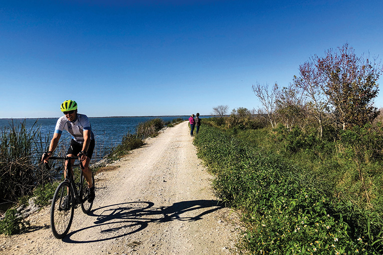
At nearly 15 miles long, the Lake Apopka Loop Trail might well be one of the most remote stretches of “hardpan” road in Central Florida. Running along the eastern shore of Lake Apopka, the trail employs old roads built by farmers who used to grow vegetables in the rich mucklands. The state purchased the property during the 1990s because pesticides sprayed on the crops virtually destroyed the lake.
Slowly rebounding, Lake Apopka is home to multitudes of alligators and wildlife—all of which are easily within view from the bike trail, which typically sits about five feet above the lake and its surrounding marshes.
The loop is popular with bird watchers and cyclists riding hybrid bikes, or ones with wider tires and a frame built to handle the often bumpy trail, which has some blacktop but consists mostly of hard dirt and gravel.
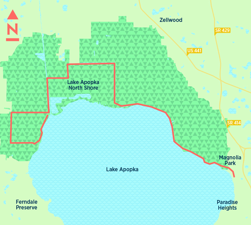
Although it is called a loop, the trail really is more of an out-and-back path. The easiest access is at Magnolia Park, 2929 S. Binion Road, Apopka. There are two other trailheads, at North Shore and Clay Island, that offer parking.
Parents thinking of taking their children for a ride should be aware that the loop has only one real restroom along its circuitous paths—a portable bathroom at an old pump house at mile marker 4. Also, there are no water fountains or appreciable shade, making an early-morning or late-evening ride the best options during most of the year.
Take note: Parts of the loop are open to car traffic Fridays, Saturdays, Sundays and federal holidays. With a speed limit of 10 mph, the one-way, 11-mile drive runs through the eastern portion of the property, beginning at Lust Road and ending on Jones Avenue. Dan Tracy
Sanford Riverwalk Trail (ROBERTO GONZALEZ)
Local
2 miles
This is a popular, relatively short path with big plans for the months and years ahead.
Right now, the Riverwalk runs two picturesque miles along the shore of Lake Monroe. There are plenty of benches to rest your legs and watch people fishing. Just a few blocks east of downtown Sanford, the Riverwalk connects several lakefront parks and is across Seminole Boulevard from Sanford City Hall. There’s plenty of parking by the trail, as well as in nearby lots.
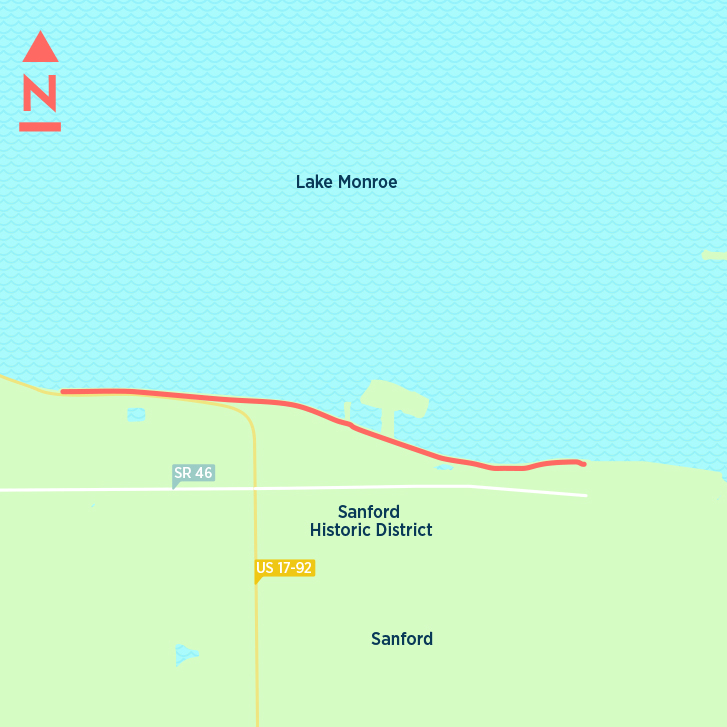
The western end of the 15-foot-wide trail is beside Central Florida Regional Hospital.
There are loads of restaurants and shops within walking distance of the trail, which typically draws more pedestrians than bikers because of its short length.
But an expansion is on the horizon. An extra 2.4 miles are planned for the western end during the coming months to link it with the Coast to Coast Connector, which, when also expanded, will eventually meet up with the Cross Seminole Trail. Another planned leg for the Riverwalk has it linking to the SR 415 Trail as part of a hoped-for Lake Monroe Loop. Dan Tracy
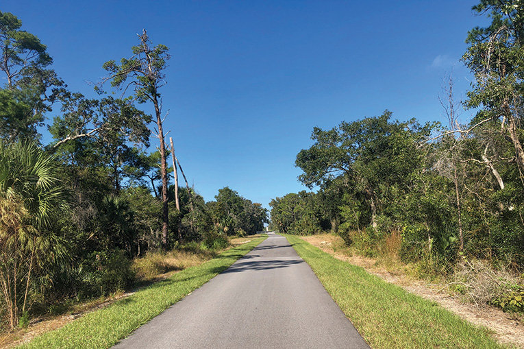
East Central Regional Rail Trail (SANDRA FRIEND/FLORIDAHIKES.COM)
Local/REGIONAL
This trail will run some 50 miles when it is completed, seamlessly joining DeBary with Titusville and Edgewater. It also will become the major eastern route in the Coast to Coast Connector slated to link the Atlantic Ocean with Tampa Bay.
One of the biggest missing pieces of the trail is a 3.5-mile section in Volusia County, between Guice Road and a trailhead at Gobblers Lodge Road in Farmton. That forces cyclists to ride on two-lane Osteen Maytown Road. Although it usually is lightly traveled, most of the cars and trucks exceed the 45 mph speed limit.
Sparse work appears to have been done on the unpaved section, with little more than a grass path now carved out of the woods.
The paved trail is amazingly flat as it goes though large swaths of Florida scrub and wetlands. About midway between Titusville and DeBary is a place known as Vergie’s Feed Station, which is a little stand offering some shade, places to sit and, most importantly, snacks and drinks. Pay what you think is fair. It’s on the honor system.
The Volusia section also provides benches along the route. Toilets are available at three locations—Cow Creek, Maytown and Gobbler’s Lodge. Dan Tracy
Listen Up!
There’s some common language riders use to communicate on trails or roads. For instance, shouting “clear” if there’s no one coming at an intersection or “car back” if a car is coming up behind the cyclist or “stick” if there’s a stick on the trail. “Or ‘snake’ or ‘pothole,’ ” adds Orange Cycle owner Deena Breed with a laugh. “Don’t assume the person behind you sees what you see.”
When passing someone, Breed says, “I just say something real friendly, like ‘good morning’ because constantly hearing ‘on your left’ on a busy trail can get annoying.” She does it about 20 feet away from the person to avoid startling him or her.
When coming upon trail users who are walking dogs or are with children—two of the least predictable trail users—Breed cautions to slow down, pay attention and give lots of warnings to avoid an accident. “ M.S.
General James A.
Van Fleet State Trail (JOHN KEATLEY/FLORIDAHIKES.COM)
Out-of-Town
29 miles
Deep in the heart of Polk County, the Van Fleet Trail stretches from one small town, Polk City, to another, Mabel, on State Road 50. As much as a third of the trail goes through the Green Swamp, an almost primordial wetland encompassing more than 320,000 acres.
Like the Lake Apopka Loop Trail, the Van Fleet path showcases a dim and distant place where wildlife sightings are common. Gators, bobcats, tortoises, feral pigs, eagles, you name it—they abound in the bog that the Van Fleet bisects.
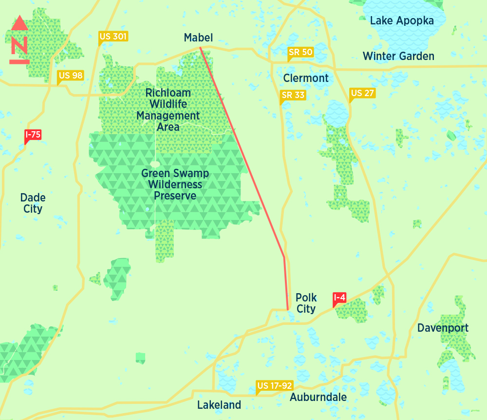
But unlike the Lake Apopka Loop, the Van Fleet is fully paved and straight, almost abnormally straight. In fact, there is basically one small curve, about five miles north of the Polk City trailhead. Other than that, it’s full steam ahead.
That amazing lack of bends and angles—as well as flatness —attracts some cyclists who enjoy riding fast. There are few intersections with roads, too, which also encourages speed.
The trail is named after one of America’s longest-serving generals, James A. Van Fleet, who lived on a ranch near Polk City before his death in 1992. He was 100 years old and had served in World Wars I and II and the Korean War. Dan Tracy
Withlacoochee
State Trail (DISCOVER CRYSTAL RIVER FLORIDA)
Out-of-Town
46 miles
he Withlacoochee State Trail spans three counties and connects its 400,000 annual users to many Sunshine State gems, such as the Withlacoochee State Forest, the 76-mile Withlacoochee State River Paddling Trail, and the Giraffe Ranch north of Dade City. Unless you’re thirsting for a 92-mile round trip, you can break the trail into customized slices thanks to its numerous entry points.
The southern part is mostly rural and great for a nice, quiet ride. Near the Owensboro Junction Trailhead at the start of the trail is Giraffe Ranch, a working ranch that offers safaris and encounters with exotic species such as giraffes, camels and rhinoceroses. If miles of paved trails aren’t exciting enough, find mountain biking trails where the Withlacoochee intersects Croom Rital Road.
The middle hunk of the trail, from Nobleton to Inverness, offers both country and small-town charm. Lake Townsen Regional Park is well-kept and peppered with towering pine trees. There’s a playground, recreation such as basketball and horseshoes, and a fishing pier and boat ramp on the Withlacoochee River.
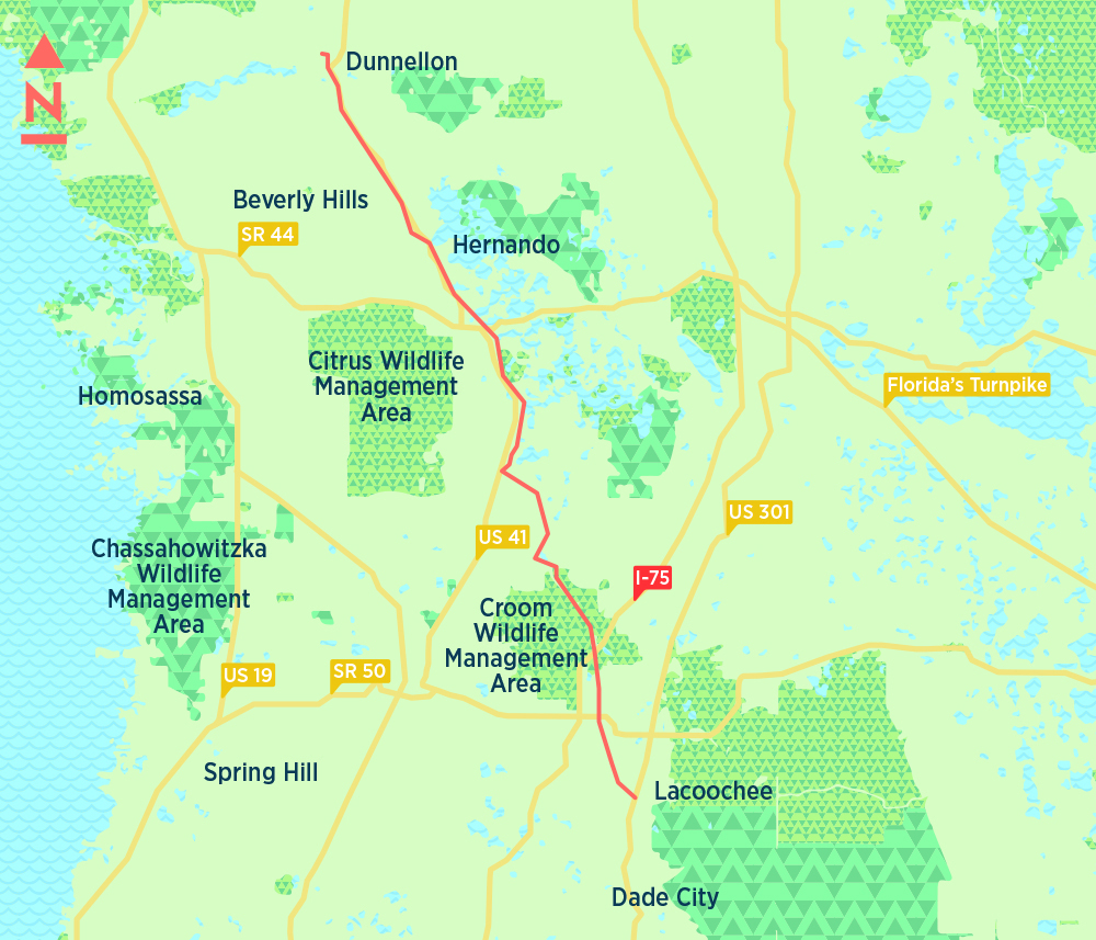
Continuing north, there’s mostly serene Florida forest, sprinkled with a few stilt homes. The trail opens to vast ranches and farms with cattle and horses near Istachatta. Depending on the day, you might not encounter another soul until nearing 136-year-old Floral City—named for its abundance of wildflowers and known for the period homes and heritage museum dotting its main street, which intersects the trail. Floral City is also home to Ferris Groves, the retail store of a nearly 90-year-old citrus farm.
Through Inverness, the trail traverses the massive Henderson Lake, passes through Wallace Brooks Park—offering stunning views from a boardwalk pier and a playground—and is near restaurants and shopping, including The Ice Cream DR, Hen House Café and Inverness Bicycle and Fitness. In the northern chunk of trail, the portion that runs through Hernando is surrounded by commercial development, and around Citrus Springs the trail hugs subdivisions.
In May, the state will begin construction on a trail extension from the northern tip of the Withlacoochee to the scenic 2.5 mile Dunnellon Trail, which boasts a beautiful bridge over the Withlacoochee River and hiking trails within Blue Run of Dunnellon Park. Another six-mile extension from the Dunnellon Trail to the Cross Florida Greenway Trail is planned for 2022. There are also plans to extend the southern end of the trail to the Hardy Trail in Dade City but this project is currently unfunded. Megan Stokes
Pinellas Trail (JIM LEUSNER)
Out-of-Town
54 miles
One of the oldest and most celebrated bike trails in Florida is the Pinellas Trail, which opened in 1990 with a 5-mile-leg through the suburbs of Largo and Seminole, eventually growing to 54 miles of urban and recreational links. The path links downtown St. Petersburg and the city’s northern suburbs to Clearwater, Tarpon Springs and beyond to the Coast to Coast Connector, which will end on the east coast in Titusville, when that 250-mile project is completed.
The core of the trail is a 36-mile leg from St. Petersburg to downtown Tarpon Springs. Eventually, an eastern trail leg back to St. Petersburg will complete a 75-mile-long Pinellas Trail Loop.
The route, formally named the Fred Marquis Pinellas Trail after the county administrator who helped make it a reality, begins in downtown St. Petersburg at Demens Landing Park along Tampa Bay with separate bike lanes and barriers. A waterfront park, the famous Salvador Dali Museum and plenty of restaurants are nearby.
The trail heads directly west toward Treasure Island, swings north through South Pasadena and across picturesque Lake Seminole. It essentially parallels the L-shaped, northbound Alternate U.S. Highway 19, runs past Tyrone Square Mall and crosses several highways via bike overpasses through old, tree-lined suburbs until it reaches downtown Clearwater. Along the way, the path navigates a few industrial parks where riding in groups is recommended. But the trail often has steady traffic and easy turnoffs to Pinellas’ numerous and popular county parks, offering a temporary oasis on hot days. The trail also has several places to detour for a quick spin to the beaches at Treasure Island, Redington Shores or Clearwater Beach.
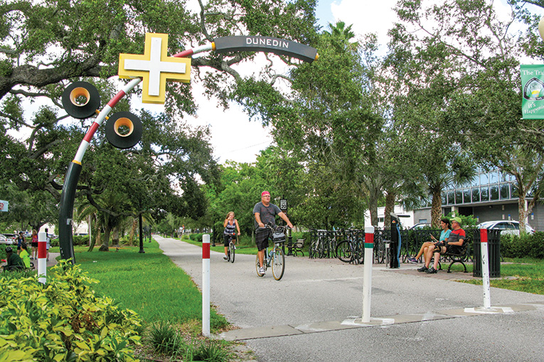
But the trail’s jewel is Dunedin, a charming little town just north of Clearwater. It has used the reclaimed railroad right-of-way as a centerpiece to revive a lifeless downtown business district crushed by the suburban malls of the 1970s and 1980s. Now, the shaded trail, its bike racks and riders are the centerpiece of its economy, attracting tourists to its festivals, bars, restaurants, ice cream shops, boutiques, galleries, museums, marina and Toronto Blue Jays Spring Training venue. Stop and grab a cool cone at Strachan’s Ice Cream; a beer at Dunedin Brewery, the oldest microbrewery in Florida; or some seafood at Bon Appetit on the Dunedin Pier. Or catch a spectacular orange Gulf of Mexico sunset.
A great ride is the 11 miles north from Dunedin’s Main Street to Tarpon Springs’ Tarpon Avenue, past old neighborhoods, more parks, a water reclamation reservoir and the Suncoast Primate Sanctuary (you’ll smell it when nearby.) There also are several quick detours to ride along the idyllic Gulf waters or head west along Dunedin Causeway to Honeymoon Island and watch kayakers do their thing. Or make a pit stop farther north on the trail at Wall Springs Park and its natural spring.
Once in downtown Tarpon Springs, past another old train depot, more pubs, restaurants and shops are scattered around. Or take a mile detour northwest and head to Tarpon Springs’ sponge docks and Greek restaurant cuisine. Back on the bike trail, you can continue north to the Pasco County line and the first segment (five miles) of the Florida Coast to Coast Connector or spin south around much of Lake Tarpon.
Overall, the trail is a great place for veteran, high-speed riders, intermediate users and newbies. Make sure you visit some of the county parks. They are quiet, fun to ride in, have lots of trees, lakes and waterways, and facilities for your pit stops. And be vigilant at busy intersections you may have to cross, because traffic is heavy. Jim Leusner
Along the Lake Baldwin Trail Loop (ROBERTO GONZALEZ)
Safety, reasonable length and entertainment are the biggest factors to consider when looking for a trail good for children. These rides hit all three marks.
By Megan Stokes
Little Econ Greenway
Rouse Road to North Econlockhatchee Trail overpass (4 miles round trip)
This east Orange County trail is a luxuriously wide, paved path that gives kids some wiggle room when they inevitably drift into the other lane. There’s a huge, covered playground at the beginning of this section (across from the Blanchard Park YMCA). A mile west is another, smaller playground—also covered. The trail parallels the Little Econlockhatchee River, which provides gorgeous views for most of the ride and a chance to see wildlife, including herons, ducks, turtles and, on occasion, alligators. Shade is spotty, but there are tons of picnic areas. Before the Econ Trail overpass is a bridge atop a hill that kids love to climb with their bikes, then turn around and speed down, so it’s a natural halfway mark. Arriving back at the starting point, follow the path running behind the YMCA to find a waterfall off the river dam and areas for fishing. Some people bring lettuce to feed the turtles on the riverbank.
Celebration Trail
(7-mile loop)
This extremely popular path in the Town of Celebration is a mix of bridges, beautiful lakes and ponds, boardwalks cutting through Florida swamp and on-street trail sections that offer a glimpse of this pristine neighborhood bubble. My kids—ages 5 and 7—loved seeing one home’s slide leading from the top balcony to the pool below. There are also several informational plaques on the birds commonly found along the trail—great for budding birdwatchers. Instead of biking the entire seven miles, we cut through Celebration Avenue for a trip to Spring Park, a gorgeous locale with a kiddie zip line, tire swing and rope-climbing structure. It also has bathrooms and water fountains. After our ride, we got pizza at Upper Crust in downtown Celebration. There is also a small trail loop behind downtown with another playground and a splash pad. Find a trail map at bikecelebration.com
A playground on Celebration Trail (ROBERTO GONZALEZ)
Cross Seminole Trail
Between Big Tree Park and Soldiers Creek Park (4.4 miles round trip)
This slice of the Cross Seminole Trail is a scenic, entertaining ride for youngsters. My kids’ favorite was the steep hills on either side of the impressively modern overpass that crosses U.S. 17-92 in Longwood.
Older children might enjoy the mountain bike trails around mile marker 16. There are beautiful streams and bridges and a thick forest surrounding this uncongested, serene trail.
Big Tree Park is home to The Senator, a 3,500-year-old National Champion Bald Cypress Tree that was lost to arson in 2012 (its stump remains). The tree lives on through a clone, The Phoenix: Its root stock was made from The Senator’s branches and therefore has the same genetic makeup. But the draw for kids is the huge playground that incorporates a faux bald cypress tree stump they can scale and climb inside. The park also has picnic areas and a boardwalk trail leading to The Senator as well as its sister tree, Lady Liberty, which is 2,000 years old. Soldiers Creek Park has six ball fields, concessions and a playground.
West Orange Trail
(Choose Your Distance)
The section of the West Orange Trail from Killarney Station to Winter Garden Station is packed with things to see and do. This 10-mile round trip is great for older kids, but the hills, crowds and speeding cyclists on this trail can make it challenging for younger children. A good indicator that your child is ready for a more advanced trail is when they are able to stick to the right lane of the trail without drifting and when they can go longer distances without complaining of boredom. There are many roadway intersections on this trail, but they aren’t terribly busy so can be easily managed with children. Some don’t-miss spots for families include Briley Farm and Oakland Nature Preserve at mile marker 1.5, the butterfly garden around mile 3.5 and the playground at Winter Garden Station. With 20 different vendors, Plant Street Market (mile 5) is perfect for lunch with picky eaters. For families with younger children, ideal 3-mile trips would be from Killarney Station to the nature preserve, and the butterfly garden to the playground at Winter Garden Station.
Lake BaldwinTrail Loop
(2.5 miles)
Very family friendly with wildlife, playgrounds, a dog park and more. Beginning and finishing near downtown Baldwin Park ensures plenty of food options.
When riding with children, always be prepared with a first aid kit, water, sunscreen and, most importantly, snacks.
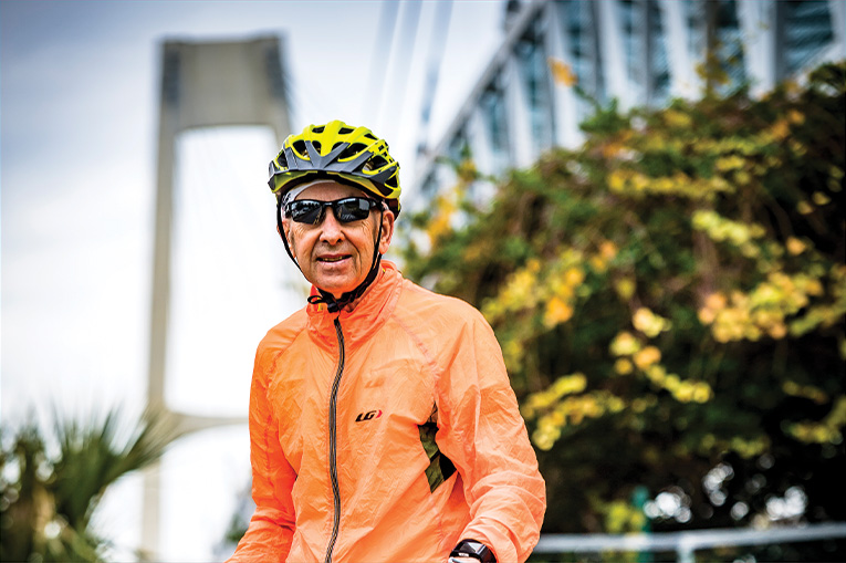
Arnold Dzick enjoys riding his electric bike along Central Florida trails. (ROBERTO GONZALEZ)
From elementary to expensive, here are some basics on buying a bike and supporting equipment.
By Dan Tracy and Jim Leusner
The old saying that you never forget how to ride a bike may well be true. But trying to figure out what kind to buy is a lot more complicated than you might think or remember.
First off, “have an idea of what type of riding you want to do,’’ says Joey Gilman, general manager of Winter Park Cycles. On pavement or off? Long distance or short? Weekends only or something more? Power-assisted outings that use an electric bike?
Then, of course, there’s the money factor. Budget often determines the ultimate purchase.
Bikes range in price from pretty cheap—$89 for a Mongoose mountain bike at Walmart—to more expensive than an entry-level Ford Fiesta—$16,000 for the Cervelo P5X triathlon bike at Gilman’s shop.
In between is an entire universe of choices at places as disparate as Walmart and Costco; specialty shops like Winter Park Cycles, Orange Cycle and David’s World Cycle; and bike makers’ online websites.
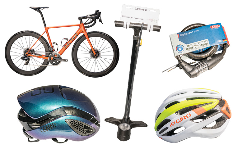
At Winter Park Cycles, from top: a Factor bike is among the many top-of-the-line choices. Accessories include pump, lock and both high-end and low-end helmets. (ROBERTO GONZALEZ)
Something else to consider is whether you want an added boost to your ride. One of the fastest-growing segments of the cycling market is for the electric-assisted bike, which employs an electric motor to make pedaling easier, increasing the speed and decreasing the amount of effort by the rider.
Deloitte, one of the big four accounting firms, predicts sales of e-bikes will quickly climb as people seek alternate means of transportation and exercise. Prices vary widely, depending on the quality—generally $400 to more than $10,000—and the batteries typically last two to six years.
Gilman’s shop does not sell e-bikes, but he says he seen enough of them in Metro Or-lando to know they are growing in popularity. E-bikes, he says, “definitely open up the market for some people.”
But here’s the bottom line for a would-be cyclist: If you are just going to cruise a couple or three miles around the neighborhood or on bike paths with young children, department store equipment likely will suffice. If you plan some serious trail or road riding, the need for quality and comfortable gear is essential—and those are best found at a bike shop, where expert help is available.
“Get a helmet before you go for a ride,” says Aryan Harney, store manager of David’s World Cycle in Casselberry. “But if you want something safer and more comfortable [than just a helmet], come to your local bike shop.”
Helmets are, indeed, essential to safety. They can be the difference between catastro-phe and just an embarrassing fall if you accidentally go down on a ride.
Walmart and Target typically have one-size-fits-all, foam-filled adult helmets such as Bell, Schwinn or other brands costing $18 to $35. At bike stores like David’s, they have three sizes with better comfort, weight and ventilation, Harney says. His helmets start at $70 and some new high-tech material designs such as Bontrager WaveCel models start at $150 with significantly increased protection from head injury, he says.
Other key equipment to consider:
- A bike pump to help repair flats or keep your tires at the proper inflation.
- Front and rear lights to improve visibility.
- A lock to secure your bike.
Gilman estimates that buying a decent bike and acquiring items like a helmet, pump, lock and water bottles comes in at around $500 to $550.
Good sunglasses are helpful, too, as are a computer or GPS unit to map and track your route (unless you use your cell phone), comfortable bike pants to cushion your bottom and maybe a rack for vehicle transport.
Those items can easily add hundreds of dollars to your start-up expenses. A pair of carbon shoes that clip into your pedals, for example, can retail for $500. Bib shorts with padding in the rear can cost $180 or more.
Although some low-tech equipment such as water bottles, tire tubes, cell phone bags and locks may be worth buying at big-box stores, it’s best to look for more sophisticated gear at bike stores. They invariably offer better components and professionally assembled bikes and accessories and also provide fitting, repairs, service and instruction on biking equipment.
Pedal the Web
Bike Florida (bikeflorida.net) is a rich resource for details on bike trails statewide, with information and maps broken down by region. Orange and Seminole county government websites (orangecountyfl.gov and seminolecountyfl.gov) have info about trails within their borders. Just search with the keywords “bike trails.’’ Ditto on Orlando’s site (orlando.gov) or the government sites of most any municipality with a bike trail nearby. Also, check out Florida Hikes! (floridahikes.com) run by outdoor enthusiasts Sandra Friend and John Keatley. It contains extensive information about bike trails, as well as hiking, kayaking and camping opportunities.
This article appears in the March 2020 issue of Orlando Magazine.